
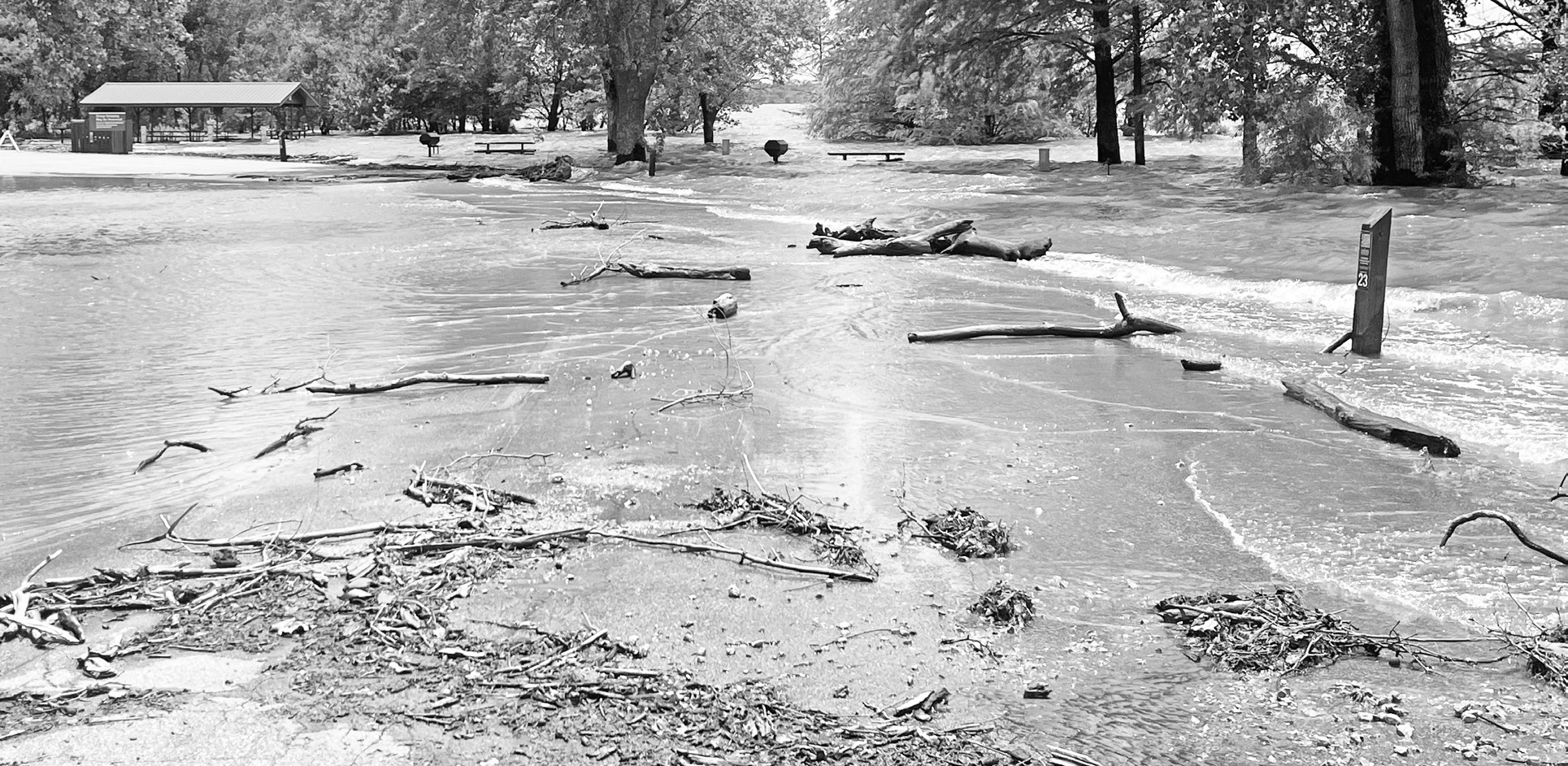
The water covering roads, campsites and recreation areas at Council Grove Lake this week is inconvenient, damaging and frustrating.
It is also evidence that the lake is doing what it was built to do.
That was the message Monday as Gary Kepley, Deputy OPM-Kansas Area for the U.S. Army Corps of Engineers, Tulsa District, gave the Council Grove Republican a private tour behind roadblocks at the lake.
The tour followed a recent conversation in which U.S. Sen. Jerry Moran told the Republican that $13.75 million in federal funding was headed to Council Grove Lake. Kepley referred funding questions to the Corps’ Public Affairs Office and did not discuss details of the funding during Monday’s tour, saying he was not authorized to speak on that issue.
Instead, Monday’s tour focused on current lake conditions, flood-control operations and why some recreation areas remain closed.
The tour showed impassable roads, submerged campsites, flood debris and wave action strong enough to move gravel, threaten road shoulders and damage recreation facilities.
For campers and lake users, the closures are disappointing, especially heading into a holiday period. For Council Grove, however, the high water is also a reminder of the lake’s primary purpose: flood control.
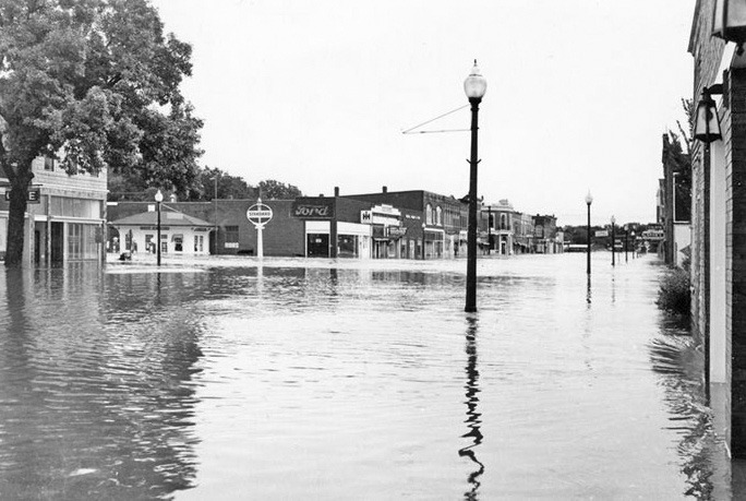
At the Corps office, photographs of the 1951 flood on Main Street in Council Grove are displayed. Kepley said those photos are sometimes used to help explain why campsites must be closed when flood water rises.
“It is painful here,” Kepley said of recreation impacts during a holiday period. “But what does that look like on Main Street if this thing is not doing what it was designed to do?”
During the tour, Kepley said many people today know Council Grove Lake as a place to camp, boat, fish and ski. Fewer remember the flood history that led to the reservoir’s construction. He said that makes it harder for some visitors to understand why recreation areas are closed when the lake is high.
Flooding had affected portions of Canning Creek, Santa Fe, Richey Cove and Kit Carson. Kepley said the parks were not entirely underwater, but roads, campsites and utilities were affected in several areas. In some places, the lake was on both sides of the road. In others, campsites were underwater or inaccessible.
Kepley said Council Grove Lake is part of a larger flood-control system. Releases are not based only on conditions at Council Grove. The Corps must also consider conditions downstream, including the Neosho River and communities farther south.
Kepley said the Neosho River at Miami, Oklahoma, a downstream choke point, was running at 196%. He said 100% would be considered bank full. Water from Council Grove takes about five river days to reach Miami, he said.
Although downstream levels had begun to fall, releases still had to be managed carefully.
“All of our gauges, all of our forecasts, all of our releases, that all works with no more water,” Kepley said. If more rain falls, the Corps must adjust. The system is designed to catch and hold water, then release it in a controlled manner so it does not add to downstream flood impacts.
That flood-control purpose creates a built-in conflict at recreation areas.
“You build campgrounds inside of the flood pool, and you need to use the flood pool, so the campgrounds go underwater,” Kepley said.
Kepley said closures are not based only on whether a campsite appears dry enough to use. Roads, buried utilities, electrical pedestals, saturated ground and potential damage all have to be considered.
In one area, wave action was breaking across flooded sites and near a campsite marker. Kepley said the waves can move gravel, erode road shoulders, undermine asphalt and damage electrical systems. Buried utilities can become a safety concern if erosion exposes or damages wiring.
As the water rises, the Corps shuts off power to affected areas. Kepley pointed out one location in the Richey Cove area where Flint Hills Electric had pulled fuses more than a week earlier to cut power to the “island” area. Even after the water recedes, electrical systems must be tested before they can be used again.
The same caution applies to roads. Some flooded roads may not appear deep, but Kepley said repeated traffic from trucks and campers can destroy a saturated road base. Once the base material under asphalt is saturated, it loses the ability to support the driving surface.
He said a road might survive one vehicle, but not repeated traffic.
The tour also showed why areas cannot reopen as soon as water disappears. Roads need time to dry. Debris must be removed. Electrical systems must be checked. Damage from wave action has to be assessed.
Kepley said the lake was about six and a half feet high during the tour. If it drops two or three feet, some road bases can begin to dry and some areas may reopen. Beach and island areas will likely take longer.
Cleanup will depend on how quickly the lake falls, whether additional rain occurs and how much damage wind and waves cause. Large debris can be removed mechanically with skid loaders, grapple buckets, tractors and rakes. In some past flood events, volunteers or students have helped pressure wash mud from campsites, tables and fire rings, but volunteers cannot work around heavy equipment during mechanical cleanup. The beach areas have already required work this season. Kepley said staff cleaned a large mat of flood debris from the Richey Cove beach area before Memorial Day weekend, using equipment and staff from Council Grove, Marion and John Redmond reservoirs. The next day, another rain event put about onethird of the debris back.
Despite the high water, parts of the lake remained open. Kepley said a good portion of Santa Fe and the majority of Canning Creek were still available, and people were camping and recreating where conditions allowed.
According to information Kepley provided during the tour, the flood-related closures at Council Grove Lake included Richey Cove campsites 5-20, closed through July 23; Richey Cove campsites 21-25 and the group site, closed through July 9; and Richey Cove campsites 26-37, closed through July 2. Kit Carson campsites 3, 6 and 7 were closed through July 23. Santa Fe Trail campsites 1-9 and 10-13 were closed through July 23. Canning Creek campsites 1, 18-19 and 27-28 were also closed through July 23.
Campsites are reserved through recreation.gov, and Kepley said the Corps updates the reservation system in real time to show which sites are available and when they can be used.
“We’re doing the best we can with what we’ve got,” Kepley said, “but Mother Nature ultimately holds the cards.”
Council Grove Lake remains a popular recreation site. Kepley said it is often described as a hidden gem, with many visitors driving past other lakes to reach it. He said the lake has some of the nicest campgrounds and parks in the system because of the work of past and present staff.
But Monday’s tour showed that the lake’s recreational value exists alongside its flood-control mission.
The 1951 photograph of floodwater filling Main Street and Monday’s view of floodwater covering roads and campsites at the lake tell two sides of the same story. One shows what Council Grove experienced before the reservoir. The other shows the reservoir holding water back.
For now, that means closed campsites, debris, damaged roads and work ahead for Corps staff. It also means Council Grove Lake is working as designed.